Deep Water and Sailboat Depth Florida Homes and Condos Information Platform
Are you searching for Deep Water Homes with no bridges
to go under. Gulf of Mexico access for deep keeled sailboats and
vessels. Let us know what you are looking for and we will research and Email you results.
We are a team of Buyers Agents at Charles
Rutenberg Realty, Florida's largest real estate office.
We represent buyers.
We have access to property for sale for the entire State
of Florida
-------------------------------------------------------------------------------------------------
Chart of Punta Gorda and Port Charlotte navigation on Charlotte Harbor
Burnt Store Marina and Country Club in Southwest Florida on Charlotte Harbor with 525 wet slips and over 200 dry storage slips, fuel dock, pump-out facility,
27 holes of challenging golf, tennis, waterfront dining, athletic club, walking/bike/golf cart paths Vessels from a minimum of 30′ up to 100 ’Annual $13.50 per foot/month + electric
View Here
--------------------------------------------------------------------------------------------------
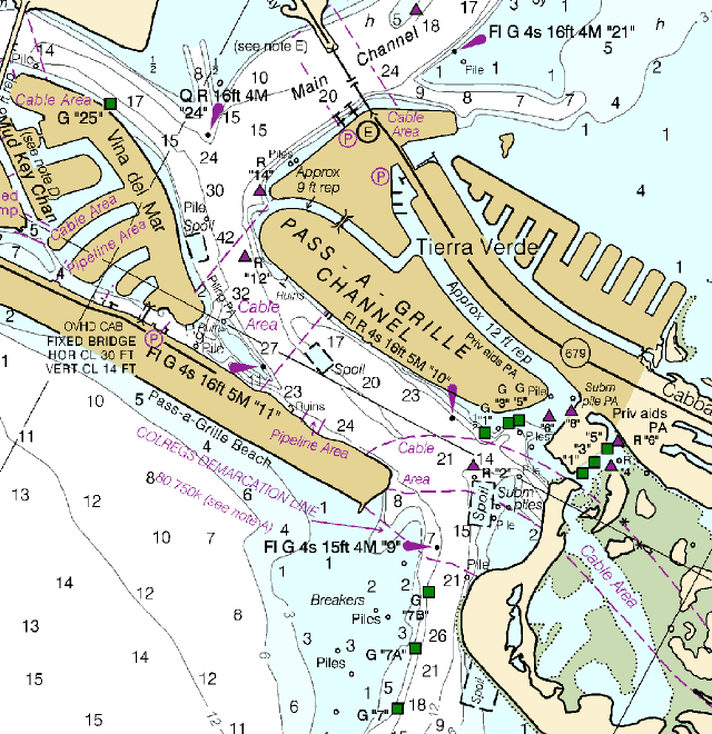
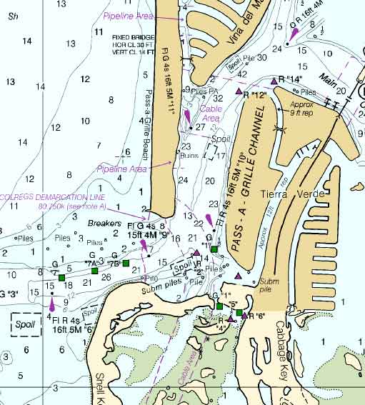
TIERRA VERDE FL CONDOS AND HOMES
The Grand Canal has 11ft average depth at low tide
TREASURE ISLAND AND MADEIRA BEACH HOMES AND CONDOS
Johns Pass Drawbridge into the Gulf- Most suitable for deep draft
sailboats
------------------------------------------------------------------------------
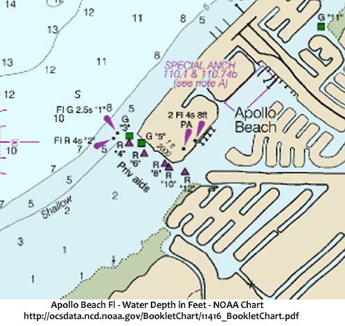
APOLLO BEACH is located in southern Hillsborough County. Downtown Tampa is 17 miles to the north, and Bradenton is 25
miles to the south.
Apollo Beach Anchorage -Lat/Lon: near 27 46.703 North/082 25.506 West
Location: lies northeast of unlighted day beacon #12 Minimum Depth: 7-15 feet
Swing Room: sufficient room for vessels as large as 50 feet
http://cruisersnet.net/111-apollo-beach-anchorage-2/
Lands end marina welcomes boats with drafts of up to 10 feet and beams
of up to 20 feet. Over one hundred wet slips to accommodate boats of up
to 100 feet
Landsendmarina.com
Most Homes in Mira Bay, Symphony Isles and Andalucia are not for sailboats
=========================
TAMPA FLORIDA
West Shore Yacht Club 149 slip Marina
Wet slip dockage for vessels up to 110' feet in length |
BACK to Waterfront Florida Homes Main Page
Fill out the contact form
Send Criteria Here
or call (727) 399-1347 for a free consultation
The most important concern is depth of water (low and high tides) near
the available homes for sale. We do not totally rely on what the listing
agents or sellers claim. We may eventually require renting a boat with a
depth finder to accurately track the water depth of the properties of
interest from the dock to the gulf.
Numbers printed on the water areas of a chart indicate the depth of the water at that spot. However, a 2 on a chart might mean two feet, two fathoms, or two meters. It is essential
to know which unit of measurement is used.
WATER DEPTH CHART
INFO
http://cruisersnet.net/category/wf-anchorages-boca-ciega-clearwater/
http://cruisersnet.net/cruisersnet-marine-map/?ll=27.84395,-82.83823333&z=14
http://cruisersnet.net/cruisersnet-marine-map/?ll=27.7087333333,-82.6847&z=15&highlight=1
http://charts.noaa.gov/BookletChart/GulfCoast
http://tampabaypilots.com
Sarasota Bay - No - low bridges / Sarasota Pass - No - too many sand bars
and water depth not consistent and too low.
Nokimis and Venice - No - North Jetty pass - No - too many sand bars and
water depth not consistent and too low.
South Venice and Englewood - No - Stump pass -No - too many sand bars and
water depth not consistent and too low.
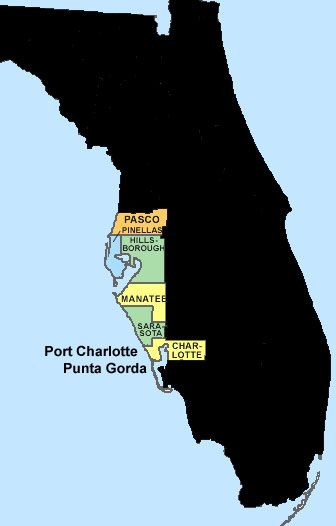
Naples, Port Charlotte and Punta Gorda
December 9, 2015 NAPLES, Fla.- Several boaters are raising complaints about
Gordon Pass after seriously damaging their boats on a sand bar. WINK News
went out to the pass to see just how shallow it was on Wednesday. It was
high tide and we got a reading just under 4 feet. When the Corps last
dredged the pass in 2010, dredgers dug to a depth of 12 feet. The pass also
was dredged in 2002.A 2014 survey showed depths in the pass below 6 feet.
Combine that with waves or wakes, and that’s not much water to keep a boat
from running aground,
NapleNewsSource
The Sand Key Bridge, together with the Johns
Pass Bridge connecting Madeira Beach with Treasure Island to the south,
forms the main thread that weaves together the beaches of Pinellas County
which we know today as Gulf Blvd.
Clearwater Pass - The controlling depth was 8 1/2 feet for a width of 150
feet from the Gulf to the Fixes highway bridge, thence 7 1/2 feet for a
width of 100 feet to a junction with the Intracoastal waterway with 1/ 1/2
feet in the left quarter of the widener at the junction
From NOAA Chart Here
TREASURE ISLAND AND MADEIRA BEACH AREA
JOHNS
PASS - bridge - magenta color denotes possible marine construction and
debris DURING THE BUILDING of the Johns Pass Bridge...which was completed 3
years ago. Obviously the chart is at least 3 years old.
-------------------------------------
Johns Pass Bridge - Drawbridge links Treasure
Island to Madeira Beach. The double draw bridge has a horizontal clearance
from 60 feet to 100 feet, and the vertical clearance over the channel of 27
to 30 feet. Hubbards marina says 70ft fishing vessels go under...at lowest
tide with no problem.
Capt Ryan (Charter boat captain) says most of the intercoastal waterway is
10 to 12 ft. johns pass - north and south pass. He charters his boat
to do depth research.
James (Charter boat captain) Says the Casino boats go thru Johns Pass into
the Gulf. He lives in Treasure Island at the Isle of Capri where there are
50ft boats docked. He says low tide around 10 foot around most of the homes.
We may be able to extend dock..
-------------------------------------------------------
Research-
From north going south. Research of bridges and passes getting into the
Gulf.
Sand Key (Clearwater) Bridge - fixed at 65 feet high
St Pete Beach, Boca Ceiga Bay and under bridge to Tierra Verde.
Fixed Bridge - The new Bayway Bridge fixed bridge is 65 foot-high.
Manatee County - Anna Maria Island - No - too many sand bars and water depth
not consistent and too low.
 |